Summary
Ru/En

# ZLS Satellite Tool
A standalone Workbench add-on for generating georeferenced satellite maps in the background. This add-on is not required by the game client or server.
Description
## Launch

1. Open the required map together with `ZLS Satellite Tool`
   (`E24E6E74D099B7A4`).
2. Open the required `.ent` file in World Editor.
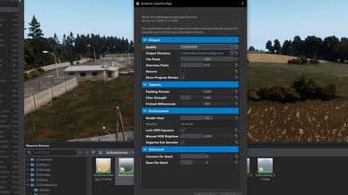
3. Select `Plugins -> ZLS Tools -> Generate Satellite Map`.
4. Select the quality level and click `Start render`.

Rendering takes place in the already open World Editor. The plugin temporarily
enables Game Mode, creates a downward-facing perspective camera with additional
coverage, and automatically traverses the entire terrain grid. An exact
per-pixel surface projection map is saved alongside each PNG. This ensures that
the dependencies and resources of the current project are used; a second Tools
instance is not launched.

After capture, World Editor returns to Edit Mode. A separate PowerShell worker
validates the PNGs and projection maps, assembles square orthorectified tiles,
builds the LOD pyramid, and writes the georeferencing data.

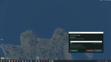
When the 'Open a live progress window' option is enabled, the status monitor
automatically opens along with the worker.

## Plugin Settings

- `Map detail` — the final spatial detail of the map:
  The smaller the value, the greater the number of tiles, output size, and
  rendering time. `Light` is intended for quickly checking boundaries and
  seams. Like the other profiles, it forces maximum terrain, object, material,
  and grass detail and draw distance. Its differences are a larger number of
  metres per pixel and the absence of an additional frame for suppressing
  glare on water. The geographic coverage therefore does not depend on the
  user's graphics preset.

  - `Light`: 1.5 m/pixel, fast preview render.
  - `Standard`: 0.48 m/pixel.
  - `High`: 0.35 m/pixel.
  - `Ultra`: 0.25 m/pixel.

  For an 8192x8192 m terrain with a tile size of 1440 pixels, the `Light`
  profile creates a 4x4 grid, for a total of 16 source frames. It should be
  used for a quick boundary and geometry check before running `Standard`,
  `High`, or `Ultra`.

- `Open a live progress window` — opens a separate progress monitor.
  Closing the monitor does not stop the render.

## Georeferencing

Tile and pixel positions are never shifted by optical feature matching. Every
tile occupies a predefined square cell within `ImageWorldBounds`, and every
pixel centre receives exact `worldX/worldZ` coordinates. Surface elevation
affects only the selection of the corresponding point in the source
perspective frame. Relief and perspective are therefore corrected without
changing geographic coverage.

## Запуск

1. Открыть нужную карту вместе с `ZLS Satellite Tool` (`E24E6E74D099B7A4`).
2. Открыть нужный `.ent` в World Editor.
3. Выбрать `Plugins -> ZLS Tools -> Generate Satellite Map`.
4. Выбрать качество и нажать `Start render`.

Рендер выполняется в уже открытом World Editor. Плагин временно включает
Game Mode, создаёт направленную вертикально перспективную камеру с запасом
охвата и автоматически проходит всю сетку территории. Одновременно с каждым
PNG сохраняется точная попиксельная карта проекции поверхности. Благодаря
этому используются зависимости и ресурсы именно текущего проекта; второй
экземпляр Tools не запускается.

После съёмки World Editor возвращается в Edit Mode. Отдельный PowerShell worker
проверяет PNG и карты проекции, собирает квадратные орторектифицированные тайлы,
строит LOD и записывает геопривязку.

При включённом параметре `Open a live progress window` вместе с worker
автоматически открывается монитор состояния.

## Настройки плагина

- `Map detail` — итоговая пространственная детализация карты:
  Чем меньше значение, тем больше тайлов, размер результата и продолжительность рендера.
  `Light` предназначен для быстрой проверки границ и стыков. Как и остальные
  профили, он принудительно включает максимальную детализацию и дальность
  прорисовки terrain, объектов, материалов и травы. Отличия — более крупный
  метр на пиксель и отсутствие дополнительного кадра для подавления блика на
  воде. Поэтому географический охват не зависит от пользовательского
  графического пресета.

  - `Light`: 1.5 м/пиксель, быстрый предварительный рендер.
  - `Standard`: 0.48 м/пиксель.
  - `High`: 0.35 м/пиксель.
  - `Ultra`: 0.25 м/пиксель.

  Для территории 8192x8192 м при размере тайла 1440 пикселей профиль `Light`
  создаёт сетку 4x4 — всего 16 исходных кадров. Его следует использовать для
  быстрой проверки границ и геометрии перед запуском `Standard`, `High` или
  `Ultra`.

- `Open a live progress window` — открыть отдельный монитор выполнения.
  Закрытие монитора не останавливает рендер.

## Геопривязка

Положение тайлов и пикселей никогда не сдвигается оптическим поиском
совпадений. Каждый тайл занимает заранее вычисленную квадратную ячейку внутри
`ImageWorldBounds`, а каждый центр пикселя получает точные `worldX/worldZ`.
Высота поверхности влияет только на выбор соответствующей точки исходного
перспективного кадра. Поэтому рельеф и перспектива исправляются без изменения
географического покрытия.
License
Arma Public License Share Alike (APL-SA)