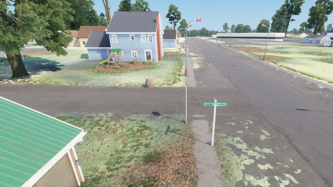
A 1:1 recreation of Lapeer, Michigan and the country around it, about 24.6 x 24.6 km, built for Game Master.

WHAT THE MAP WILL COVER
- Lapeer: downtown along Nepessing Street and M-24, the DeMille Road retail strip, the hospital, the schools and the grounds of the former Lapeer State Home (Oakdale).
- Lake Nepessing, Elba, Hadley, Farmers Creek and Metamora, with the farmland, woodlots, drains and gravel roads between them.
- I-69 and M-24 edge to edge, the railroad, the power lines and the trails.

HOW TO PLAY
Load LapeerMI, pick "Lapeer, Michigan - Game Master" in the scenario list and host. Loading can take a minute or two (about 9 million trees and bushes). The host and admins start in the Game Master editor with every vanilla faction, vehicle, prop and composition; players spawn at the default spawn points (downtown Lapeer, the hospital, Metamora, Elba, Hadley), which the Game Master can move, re-faction or delete.

STATUS (0.1.5 alpha)
Work in progress. What is in this build:
- The real ground: terrain heights from USGS lidar on a 2 m grid, a satellite map from aerial imagery and ground surfaces (grass, fields, forest floor, asphalt, gravel and more) painted from land-cover maps.
- I-69, M-24 and the public roads, paths and trails, the railroad and its bridges; driveways to the houses (about 10,900).
- Lakes and ponds; about 9 million trees and bushes in the forests, woodlots and wetlands; street and yard trees.
- Power lines with poles and wires, the first house service drops, street lights, traffic signals, road signs, rail crossing gates, fire hydrants, manholes and storm inlets.
- About 25,000 houses, farm buildings and outbuildings across the whole map, as generic stand-in models.
- Landmark buildings: downtown Lapeer's blocks and storefronts, M-24 businesses, the DeMille Road / Genesee Street retail sites (the big stores in detail, the rest as simple shells), the hospital, the schools, Lapeer West, Elba and Hadley stand-ins, the Lake Nepessing docks, the solar park and parts of the State Home grounds (cemetery markers, trail structures, pavilion, shelter, weir).
- New in 0.1.5, a streetscape pilot around downtown: curbs, ramps and drive aprons, STOP and street-name signs, lit street lights on Main and Nepessing Streets, yards (mailboxes, beds, fences, pools, play sets) and Anrook Park; pylons, dealer flags and drive-thru curbs on M-24.
- The in-game map (M key): roads, driveways, buildings, power lines and water on a shaded background with the forests, and the names of the towns and lakes.
Not yet in 0.1.5 (planned for 0.1.x):
- Detailed models for most houses, farms and barns (generic stand-ins for now).
- House service drops outside the pilot areas.
- Detailed models for the DeMille Road outparcels and strip centres (simple shells for now).
- The ruins and the other buildings of the State Home grounds.
- Roads do not reshape the ground yet, and there is no navmesh yet, so Game Master AI will not move.
Expect large changes between versions; the change notes list what each version adds.

NAMES
Towns, roads, lakes, schools, churches and public bodies keep their real names. Businesses carry parody names and signs of our own design; this is a fictional rendition for Game Master, not affiliated with or endorsed by any real business, agency or institution.

REQUIREMENTS
The base game only. No other mods needed.

CREDITS AND DATA LICENCES
- Map data (c) OpenStreetMap contributors, available under the Open Database Licence (ODbL) 1.0: openstreetmap.org/copyright (Geofabrik Michigan extract of 24 Oct 2026). Road, building and vegetation layers derived from it stay under ODbL.
- Building footprints: Microsoft Global ML Building Footprints (release 2026-02-03), ODbL 1.0.
- Elevation: USGS 3D Elevation Program (3DEP) 1 m lidar DEM (Lapeer, Genesee, Oakland and Macomb county projects, 2015-2016), public domain.
- Aerial imagery: USDA Farm Service Agency, National Agriculture Imagery Program (NAIP) 2022, public domain.
- Land cover and crops: USDA NASS Cropland Data Layer 2025; USGS / MRLC National Land Cover Database 2021; public domain.
- Wetlands: U.S. Fish and Wildlife Service, National Wetlands Inventory, public domain.
- Hydrography: USGS National Hydrography Dataset, public domain.
- Road centrelines and railroads: Michigan Geographic Framework, State of Michigan / MDOT open data, as is, no endorsement.
- Boating access sites and watercraft control areas: Michigan DNR open data, as is, no endorsement.
- History of the State Home grounds: Lapeer District Library; "Oakdale: The Lapeer State Home" (Images of America); Oakdale Trails map (CRAMBA 2020).
No agency named above endorses this mod. Google Maps, Google Earth and Street View were used only as visual reference; no Google imagery or data is in the mod. Base-game assets belong to Bohemia Interactive and are referenced, not included.

LICENCE
Arma Public License (APL). The data credited above stays under its own licence.